5 Great Backpacking Trips Within a Day’s Drive of Alabama
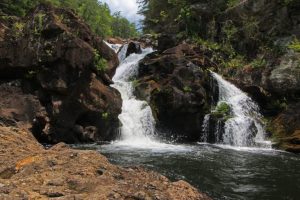
Georgia’s Cohutta Wilderness is home to the popular Jacks River Falls.
Please note: due to local and state guidelines surrounding the Covid-19 pandemic, some information below may not be accurate. Before you travel and plan your next adventure, make sure to check each business/park/campsite for any closures or guidelines and for the most up to date information.
Have you explored every inch of the Sipsey Wilderness? Been there and done that in the Talladega National Forest? Then it’s time to expand your horizons, break through the border, and sample some of the great backpacking treks in the states that border Alabama.
The best part is that you won’t have to travel far to get there. Within a day’s drive you’ll find remarkable stony crags with breathtaking panoramic views and towering waterfalls that roar down rocky cliffs forming rainbows in their spray. Just across the Alabama state line there are plenty of great places to go backpacking, and here are five of our favorites.
1. Blood Mountain Wilderness – Cleveland, Georgia

If you drive about 150 miles northeast of Fort Payne, you’ll reach Georgia’s famous Blood Mountain Wilderness. Boasting rugged peaks and rock outcroppings with awe-inspiring views, the wilderness spans 7,742 acres in the Chattahoochee National Forest.
Throughout the wilderness you’ll encounter waterfalls, lakes, and streams, plus a remarkable series of falls and cascades along Blood Mountain Creek, one of which slices through a 20-foot cut in the rock to create a turbulent stream.
The wilderness itself is named for its centerpiece, the 4,459-foot-tall Blood Mountain, the tallest peak in the state, whose summit offers great views, especially in the fall when the trees display brilliant colors.
Even though the mountain is located deep within some challenging terrain, it is still a very popular destination, even for casual hikers, and it can get quite crowded. The reason—the Appalachian Trail snakes its way to the summit where a 2-room CCC stone shelter sits waiting for hikers. (If you can visit mid-week or at times of the year when trail traffic is low, the shelter is certainly worth a visit, as a rock outcrop near the structure offers a stellar view of forested ridges rolling to the horizon.) During peak hiking seasons, you can avoid crowds on Blood Mountain by taking trails that are less travelled. Along the western slope, there are some fantastic trails that wind around the surrounding mountains and lead to Blood’s summit.
One of the best is the 16-mile (round trip) hike to Cow Rock Mountain along the Byron Reece Trail. For a short distance it connects to the A.T. and takes you to the top of Blood Mountain. During much of the trek you’ll enjoy inspiring views of the surrounding mountains, and you’ll have your choice of several backcountry campsites. (The campsite with the best view sits on top of Wolf Laurel Top.)
2. Cohutta Wilderness – Cisco, Georgia

About 100 miles northeast of Fort Payne there is a truly remarkable backpacking destination, where towering waterfalls thunder down weathered sandstone cliffs, cool natural springs offer respite from the hot summer sun, and the views are simply spectacular. It’s called the Cohutta Wilderness, the largest wilderness area east of the Mississippi River and one of the most remote sections of the North Georgia highlands.
Covering nearly 37,000 acres, the Cohutta has more than 100 miles of trails that weave their way through a lush landscape of hemlock trees and rhododendron. Its many paths intersect to offer seemingly endless hiking possibilities with challenging climbs, plenty of creek and stream crossings, and incredible panoramic views.
One of the most popular paths is the 18-mile round-trip Jacks River Trail which steeply descends into a gorge to meet up with its namesake river. The trail meanders through an emerald forest lined with fragrant wildflowers in season and crosses the clear, cool river 18 times, affording you plenty of chances for a swim. Keep in mind that the trail passes the popular Jacks River Falls and it can get crowded in the summer when locals and tourists make the trek to cool down in the waterfall’s pool.
Because severe weather has damaged trails and trailheads in the past, you should visit the USDA Forest Service website and check the status of trails. Also, prior to your trip, contact the Conasauga Ranger District to get a map of the wilderness.
3. South Cumberland State Park/Fiery Gizzard – Sequatchie, Tennessee

Located just 78 miles northeast of Huntsville, South Cumberland State Park in Sequatchie, Tennessee, is perched high atop the Cumberland Plateau. It includes more than 90 miles of hiking trails with everything from lazy walks through seas of wildflowers to strenuous, rocky climbs to incredible views from open ridges.
The park is actually comprised of nine different wilderness and natural areas, one of the most popular being Fiery Gizzard and its Fiery Gizzard Trail, which measures 12.5 miles one way. With a name like Fiery Gizzard you know this has to be an amazing hike—and it is. In fact, Backpacker Magazine once ranked it as one of the top 25 trails in the nation, and for good reason. The forest is lush, the views of the rocky gorges and outcroppings are incredible, and rumbling waterfalls and streams tumble through the landscape.
You’ll find maps and additional information on all of the hikes within the park, including Fiery Gizzard, on the Friends of South Cumberland website.
4. Savage Gulf Natural Area — Palmer, Tennessee

Drive 90 miles northeast of Huntsville and you’ll reach Palmer, Tennessee, and the Savage Gulf Natural Area, whose name certainly conjures up visions of true hiking adventure.
Savage Gulf includes more than 15,000 acres of pristine forest with 55 miles of trails that offer what is arguably the best hiking in the South. Along the rugged, rocky trails you can take in some the fascinating history of the region at places like the old Laurel Mill site and the remnants of an old moonshine still.
But, it’s the beauty of Savage Gulf that really lures backpackers, as trails wind among towering sandstone cliffs, including the Stone Door bluffs which rise 150 feet. You can peer into the deep canyon that nature has carved over the centuries and experience the thundering waters of Greeter Falls, where a 15-foot cascade flows down to a lower 50-foot curtain of water.
To learn more about the Savage Gulf Natural Area, visit the Tennessee Department of Environment and Conservation website and pick up a map of its trails from the Friends of the Cumberland.
5. Blackwater River State Forest – Munson, Florida

While Alabama is within reach of many challenging hikes, it’s also possible to drive a few hours to reach easier trails that suit beginners but also offer interesting features that advanced hikers will enjoy. From Gulf Shores, if you travel northeast a little less than 90 miles to Munson, Florida, you’ll find great hiking in Blackwater River State Forest.
Blackwater River is the largest of Florida’s three state forests and includes more than 189,000 acres of rolling hills and towering longleaf pines. Several trails crisscross the forest and allow hikers and backpackers to travel a day or more and visit its many lakes, streams, and rivers and view a wide range of wildlife, including the Florida Black Bear.
The forest’s centerpiece is the dark, tannin colored Blackwater River that courses through the pines as it flows south to the Gulf of Mexico. As you follow the 21-mile (one-way) Jackson Red Ground Trail you’ll follow the river, and you can relax on its banks and watch bald eagles and red tail hawks soar overhead.
The orange-blazed Jackson Red Ground trail was originally an Indian trading path and is now part of the Florida Trail, which stretches from Key West to Pensacola. The trail is named for its red soil and General Andrew Jackson, who traveled this route on his march from the Apalachicola River to Pensacola during the First Seminole Indian War of 1816.
Ready to be outdoors this Summer? We have the Summer outdoor gear you need to get you back on the trails! We want everyone to enjoy the outdoors, and we work to build loyalty one connection at a time. Visit one of our stores or take advantage of our shipping or curbside pickup! #BeOutdoors
Written by Joe Cuhaj for RootsRated in partnership with Blue Cross Blue Shield of AL and legally licensed through the Matcha publisher network. Please direct all licensing questions to legal@getmatcha.com.
Featured image provided by Alan Cressler